Designing a Robust and Resilient Marine Protected Area Network in Lesser Sunda Ecoregion
Location
Lesser Sunda Ecoregion, Indonesia
The challenge
At the southern end of the Coral Triangle, the Lesser Sunda Ecoregion (LSE) stretches from Bali to Timor-Leste, covering an area of more than 450,000 km2. The coral reefs of the region are highly diverse and have high levels of endemism, and six species of endangered sea turtles nest on the beaches of many small islands. This area is a major migratory corridor for cetaceans between the Indian and Pacific Oceans, with 22 species of marine mammal including blue whales and sperm whales recorded. Other large marine species such as dugongs, manta rays, and whale sharks are also common in this region.
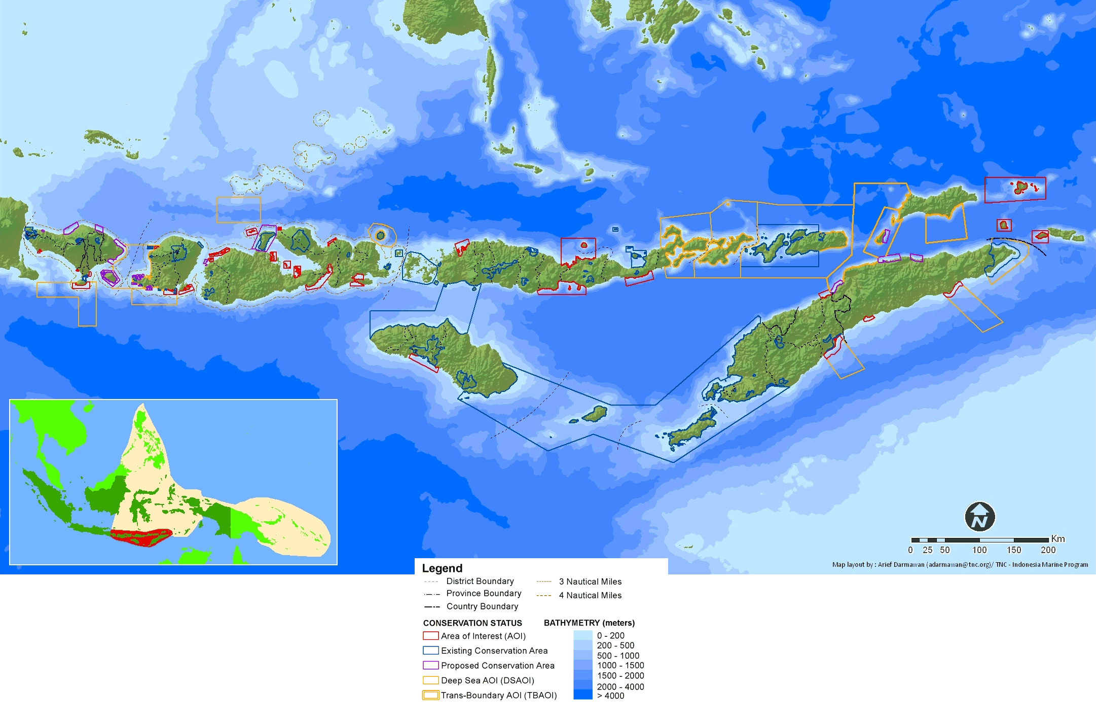
A scientific design of a resilient network of marine protected areas in the Lesser Sunda Ecoregion, encompassing 3 provinces and two countries.
One of the exceptional features of this region is the steep and dramatic underwater landscape. Just a few kilometers from the coast, the seafloor drops from shallow coral reefs to canyons and seamounts at depths of up to 2000 m, creating “deep sea/near shore” habitats. The passage of the Indonesian Throughflow (ocean current) between the narrow channels of the islands generates exceptionally strong currents. Persistent seasonal cold-water upwellings are an important feature of this region and drive the high productivity that supports fisheries and cetacean populations. These could also be a key factor in conferring resilience to the growing threat of rising sea surface temperatures associated with climate change. If properly protected, the Lesser Sunda Ecoregion could become a refuge for marine life and productive fisheries amid global climate change.
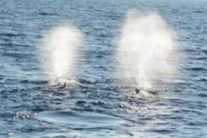
Sperm whales in Savu Sea waters. Photo © Yusuf Fajariyanto/TNC Indonesia Oceans Program/2015
Although the islands of the Lesser Sunda are sparsely populated (around 16.5 million people live on hundreds of islands over thousands of square kilometers, making it one of the least densely populated areas in Indonesia), resource management issues include destructive and overfishing and harvesting of cetaceans and turtles, coastal development, and mining. These practices threaten both conservation values and sustainable resource use. Developing a marine protected area (MPA) network is one strategy to reduce these threats and, by incorporating principles of resilience, to also address the threat of climate change.
Actions taken
The Nature Conservancy-Indonesia Marine Program (TNC-IMP) worked with the national, provincial and district governments, local communities, NGOs and universities from 2006 to 2011 to design a resilient network of MPAs for the Lesser Sunda Ecoregion. The MPA network design was developed through a process that included both detailed scientific assessment and an extensive stakeholder consultation process. TNC-IMP facilitated workshops on marine protected areas that were attended by more than 1,000 participants and led technical MPA training initiatives for around 200 participants from national and local government agencies, local universities, marine research institutions, local communities, NGOs, as well as the fishing and tourism industries. The design process included:
- Development of ecological and socioeconomic MPA network design criteria that include principles of resilience
- Development of a GIS database that includes the best available information on key conservation features, threats, and uses of the area
- Application of state-of-the-art conservation planning tools (Marxan)
- Collection of input from government agencies, local stakeholders, and scientific experts through a series of workshops and meetings
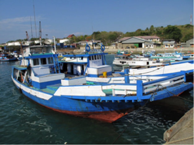
Tuna boats, Kupang. Photo © Joanne Wilson/TNC
The design for Lesser Sunda MPA network includes 100 protected areas — 86 coastal reserves and MPAs for coral reefs, mangroves and seagrass that are linked to 14 larger offshore MPAs. The offshore MPAs encompass deep sea habitats important for endangered species such as blue whales. The MPA network design builds on existing and planned MPAs and identifies additional areas for development of coastal and deep sea MPAs in the future. The network includes:
- 23 existing terrestrial reserves that are adjacent to the coast and encompass intertidal habitats, such as mangroves or turtles nesting beaches.
- 14 existing MPAs that represent coral reefs, seagrass, mangroves, turtle nesting beaches, and associated habitats and species.
- 19 areas that national, provincial, or district governments have proposed as MPAs but have not yet been declared.
- 30 additional areas of interest that have been identified for inclusion.
- 14 deep sea areas of interest — three of which encompass transboundary waters between Indonesia and Timor-Leste.
- Together, the 100 protected areas incorporate all important ecosystems and species.
Refining the 2011 Lesser Sunda MPA Network Design
It is important to note that the previous MPA network design identified in 2011 represents the views of scientists and key stakeholders, based on best available information at that time. The design was expected to meet resilient MPA design criteria while minimizing impact to local communities and other stakeholders. However, there has been no ground validation of the design. Thus, the design will likely change following new field assessments or more detailed discussions with governments, local communities, and other stakeholders.
More thorough data collection and analysis was needed to update the data for the 2011 design of Lesser Sunda Ecoregion MPA network. Several activities were carried out to gather the information. First, better imagery was acquired. Next, there was participatory mapping and in-depth study of cetaceans. The gathered information was incorporated into the biophysical and socio-economic principles for the updated MPA network design. A revised habitat/coastal ecosystem map was derived from RapidEye imagery (2014) with 5 m resolution. Six classes of benthic habitat were recorded, namely live coral, dead coral, rubble, sand, macroalga, and seagrass. The imagery was much more accurate than the former Landsat analysis that was only able to identify coral and seagrass ecosystems. In 2016, the analysis was also validated by ground-truth surveys by TNC. Participatory mapping was conducted between June and December of 2015. The site visits, analysis of respondents’ questionnaires and digitation of ground truthing activities provided extensive, updated information on socio-economic data, resource uses, and threats in the ecoregion. TNC, in collaboration with East Nusa Tenggara UNICONSUFISH (a consortium of 6 universities for Sustainable Fisheries initiated by TNC) and an additional two universities from Bali and West Nusa Tenggara, mapped 153 coastal villages in 36 out of LSE’s 42 districts. The participatory mapping of coastal and marine resources shows mangrove logging to be the most pervasive threat. It occurred in 17 out of 36 districts surveyed. Coral reef destruction, through bombing and harvesting, was the second most pervasive threat. Cetacean studies provided information on migratory corridors. The socio-economic and biophysical data gathered during the assessments informed conservation targets through a Marxan analysis.

Participatory mapping process in Lesser Sunda. Photo © TNC Indonesia Ocean Program

A refined scientific design of a resilient network of marine protected areas in the Lesser Sunda Ecoregion. Photo © TNC Indonesia Ocean Program
2017 Updates to the Lesser Sunda MPA Network Design
The refining and analysis of updated data resulted in 77 MPA networks covering 7.56 million hectares. The networks include:
- 14 Areas of Interest (AOIs), which are potential MPA network sites based on the analysis. Nine of these are new areas and 5 are older areas in Bali (Melaya Extend), NTB (Mangsit, Tatar Sepang) and NTT (Tarimbang and northern part of Wetar)
- 35 existing MPAs that have been formally established as MPAs by Ministerial Decree
- 28 proposed MPAs that have not been gazetted through Ministerial Decree
The MPA network changed between 2011 and 2017. In 2017, sixteen AOIs changed their status to proposed MPAs. By 2017, the proposed Nusa Penida MPA got legal recognition and became an existing MPA. TNC’s Indonesia Marine Program also found errors in the previous 2011 design. Satonda MPA was misclassified as an AOI in 2011 even though the area had been established as a protected area by Ministerial Decree in 2009 (SK 598/Menhut-II/2009). It is now classified as an existing MPA in the 2017 design. Also, Batuidu MPA in Rote reverted to an AOI in 2017 because the area was omitted from the Savu Sea Marine National Park (MNP) area.
Of the 77 MPAs in the 2017 updated design, 69 are shallow marine MPAs/AOIs. The 3.35 million hectare Savu Sea MNP includes both shallow coastal and deep-sea habitats. There are also seven deep sea MPAs/AOIs, three of which are trans-boundary MPAs/AOIs. Deep sea habitat is critical for local marine mammal diversity.
This updated design shows a 23% decrease in the number and area (from 9.79 million ha in 2011 to 7.56 million ha in 2017) of MPAs in the network from the Wilson et al. 2011 design. This happened because the 2017 design uses the Ministry of Environment and Forestry (MoEF)’s delineation of LSE boundaries, which encompasses the waters of West and East Nusa Tenggara. Thus, an area of 865,000 ha incorporated during the 2011 analysis was omitted in the 2017 design including two AOIs in Maluku Province, and 9 AOIs in Timor-Leste. Additionally, 900,000 ha of deep sea AOIs in Bali and NTB (the Lombok Strait, Southern of Bali, Southern of Lombok, Northern of Sumba) were included in the 2011 design but omitted in the 2017 design; these are some of the busiest maritime highways in Indonesia. Pushing forward with the conversion of such AOIs into MPAs could lead to conflict between the diverse interests of marine users. Another reason is because there are revisions to the sizes of AOIs due to better information or due to Ministerial or Governor Decree.
The 2017 design uses the same conservation targets as the 2011 design. There is no change in conservation targets for turtle nesting areas, feeding areas, aggregation sites, pelagic habitats, important bird areas, and dive sites. However, percentages for five other targets of shallow marine habitat (coral reefs, mangroves, seagrass and estuaries; whale and dugongs in shallow coastal waters; areas known to be important for dolphins; important habitat for rare and/or endangered species such as mola-mola, manta rays and sharks; and dive sites) and its sub-class are modified for different reasons regarding better data and updated information. All these conservation targets are relatively fulfilled through the 2017 Marxan analysis.
TNC has played a leadership role in developing and applying design principles to ensure that MPA networks are resilient to the threat of climate change. The updated 2017 design also incorporates results from a surface sea temperature study carried out by TNC in 2015. The study identified coral reefs that may be resilient to climate change. Areas of low and high historical exposure were identified based on historical temperature data. The results showed:
- 8% of areas have low historical exposure [<3 thermal stress events (1985-2012) and past rates of temperature increase (<0.1 °C/decade) are low]
- 4% of areas have high historical exposure [>6 thermal stress events (1985-2012) and past rates of temperature increase (>0.3 °C/decade) are high]
- 26% of areas have lower projected future exposure [<13 thermal stress events (2040-2060)]
Past temperature patterns may not be indicative of future patterns, so areas with lower projected future exposure to thermal stress were identified using dynamical climate model downscaling. The 2017 MPA network design covers 48% of areas of low and high historical exposures as well low projected future exposures. The inclusion of high historical exposures areas into MPA network design will help conserve proven resilient coral reefs. Whereas the inclusion of lower projected future exposure areas with good mixing, upwelling and currents, into MPA network design will ensure the availability of coral refugia. This coral refugia can provide coral larval stocks for adjacent areas that might be prone to thermal stress thus enabling a resilient MPA network design.
Key features of the Lesser Sunda MPA network design include:
- The first resilient MPA network design at the ecoregional level in the Coral Triangle.
- The application of large scale marine spatial planning in a data deficient area which required innovative approaches including: less reliance on computer-based decision support tools and more reliance on the use of expert mapping and input from key stakeholders.
- Incorporation of the principles of resilience, including 20% to 30% of each habitat type, protection of key species and habitats, and inclusion of habitats that may be resilient to increasing water temperatures such as areas of upwelling or high temperature variability such as high historical exposure coral reef areas and lower projected future exposure coral reef areas.
- The inclusion of socio-economic data, resource uses, and threats in the ecoregion will decrease the future conflict of resource use in the region.
- An extensive stakeholder consultation process including expert mapping exercises, scientific peer review and consultation with relevant government agencies in the region.
How successful has it been?
A new MPA, Savu Sea National Marine Park (over 30,000 km2), was gazetted by the Indonesian Government in 2014. The Ministry of Marine Affairs and Fisheries (MMAF) agreed to adopt the design as the primary reference for establishing MPAs in the Lesser Sunda Ecoregion and to include the design in marine and coastal spatial planning at provincial and national levels. The scientific design of the Lesser Sunda MPA network and the accompanying information database are excellent resources for central and provincial government agencies that have guided their coastal and marine planning in the Lesser Sunda Ecoregion. These products provided a starting point for supporting finer scale site-based planning for design and implementation of individual MPAs.
With the facilitation from TNC, the MPA Network design was adopted by the East Nusa Tenggara Province into their Marine Spatial Plan and legalized in 2017 through Provincial Regulation.
TNC-IMP supports relevant government agencies in the establishment and implementation of Nusa Penida MPA and Savu Sea Marine National Park and is providing training and technical input to policy and MPA design in Timor-Leste.
Lessons learned and recommendations
- Producing a good scientific design for a robust and resilient MPA network is an important step to promote marine conservation in a large marine ecoregion such as the Lesser Sunda.
- A good scientific design alone will not guarantee marine conservation success or the establishment of MPAs or MPA network.
- Application of marine spatial planning is expected to address multi-sectoral interests and conflicts of resource use.
- A marine protected area management effectiveness framework must also be developed and introduced across the MPA network to ensure that the MPAs established are managed in high standard and functional to benefit conservation and other development needs in the region.
Funding summary
Anonymous Funder BMUB Germany (2009-2010) and (2012-2017)
USAID (2009-2015)
Tahija Foundation (2018-2023)
Lead organizations
The Nature Conservancy (2009-2019)
Yayasan Konservasi Alam Nusantara (2019-present)
Partners
Ministry of Marine Affairs and Fisheries — Indonesia
Ministry of Agriculture and Fisheries — Timor-Leste