Designing a Marine Protected Area Network in the Federated States of Micronesia
Location
Kosrae and Yap, Federated States of Micronesia
The challenge
The Federated States of Micronesia (FSM) is comprised of 4 states (Yap, Chuuk, Pohnpei, and Kosrae) and includes 607 islands spread over 1 million mi2 of the western Pacific Ocean. Its coral reefs, estimated to cover 14,517 km2, are home to nearly 1,000 species of fish and over 350 species of hard coral. The majority of people living on these small islands depend on natural resources for their food, livelihoods, and traditions. These resources are threatened by pressure from rapid population growth, overharvesting, habitat destruction, changing cultural practices, invasive species, and climate change. Over the last two decades, this area has experienced at least five highly destructive typhoons (i.e., 1990 in Pohnpei, 2004, 2012, 2015, and 2019 in Chuuk and Yap), as well as some bleaching, with limited mortality (e.g., 1998 20% bleaching in Yap and 2004 minor bleaching in Kosrae and Pohnpei).
Actions taken
In 2003, the FSM completed a National Biodiversity Strategy and Action Plan (NBSAP), with the goal of protecting and sustainably managing a full representation of the country’s marine, freshwater, and terrestrial ecosystems. The government of the FSM, the U.S. Forest Service, The Nature Conservancy (TNC), university scientists, and local experts also drafted “A blueprint for conserving the biodiversity of the Federated States of Micronesia” (the FSM blueprint) in order to begin to address this goal. A total number of 130 areas of biodiversity significance (ABS), including 86 coastal and marine sites comprising 260,948 ha (over 1,007 mi2), were identified nationwide. The NBSAP was updated in 2018. The revision process involved extensive research to identify the status of biodiversity within the FSM, and the threats it is facing, followed by a series of multi-stakeholder consultations in each of the four states. Stakeholders included officials from national, state and municipal governments, regional, state and community NGO representatives, technical experts, scientists, and researchers and educators involved in environmental education. These stakeholders assessed the initial NBSAP for relevance and ongoing progress, updating the Objectives and Actions within the NBSAP as required to ensure it responds to the present status of biodiversity within the country. Additional information gathering was undertaken with women’s groups in each of the four states. The outputs of these consultations were then integrated into a single revised NBSAP that was subsequently validated through a two-day workshop. It should be noted that this revision process also involved the development of a state Biodiversity Strategy and Action Plan (BSAP) for each of the four states.

DeVantier, Kirino Olpet, Eugene Joseph, Emre Turak pick sites at Ant Atoll during the Pohnpei Rapid Ecological Assessment. Photo © Louise Goggin
In 2005 to 2006, Rapid Ecological Assessments were conducted in all four FSM states to assess the existing MPAs and identify potential new sites based on habitat types and threat status. In 2011, two major conservation bills were signed into law in Pohnpei. The first bill amended the Sanctuary and Wildlife act, adding four protected sites (including over 1500 ha of reefs and mangroves) to become part of the Pohnpei protected areas network. This law significantly increased the biodiversity conservation coverage in Pohnpei. Kosrae also put in place a natural resource management and conservation act that recognizes a Protected Area System (PAS). Significant progress has been made in terms of legislation around PAS. All 4 states have laws and there is a national framework. The MPAs in Chuuk and Yap, remain community based as land tenure for reefs is different (e.g., in Yap the reefs are owned by the village, and in Chuuk there are individual reef owners). The four States of the FSM (Chuuk, Pohnpei, Kosrae and Yap) each have their own PAN laws and have begun the process of operationalizing their PAN networks.
FSM has committed to achieving the goals of the Micronesia Challenge (MC), an ambitious initiative by the jurisdictions of Micronesia to effectively conserve at least 50% of their near shore marine resources and 30% of their terrestrial resources by 2030. To begin to address this challenge, a core team led by the FSM PAN coordinator, comprised of representatives from the FSM government, the Micronesia Conservation Trust, and TNC, has been working with State government and local conservation NGOs to raise awareness and build support for protected areas. With the help of the core team, the states are also working toward a standardized monitoring program to measure some key regional indicators, to assess broad trends in the country, and to track progress toward achieving the goals of the MC. Three working groups (marine, terrestrial, and socioeconomic) were established to develop the standardized monitoring program for all MC jurisdictions. A standardized marine monitoring protocol was developed and implemented, and baseline data have been collected on all the main islands. Both the terrestrial and socioeconomic monitoring protocols have been finalized and the data collected. Ten years of data has been collected using the marine monitoring protocol.
In order to assist the FSM jurisdiction to determine their progress toward meeting the Micronesia Challenge goals, TNC conducted a Gap Assessment of all four FSM States (Yap, Chuuk, Pohnpei, and Kosrae). The process involved consultation with relevant stakeholders (multi-government agencies, local NGOs and community representatives) in each of the four states to collect relevant data to be able to conduct the analysis. The assessment took place in three sequential phases:
- Phase 1 involved determining the coverage of current protected areas, and was completed in December 2009. The results of Phase 1 found 6.4% of marine ecosystems and 14.6% of terrestrial ecosystems were covered by protected areas.
- Phase 2 analyses were completed in December 2009 to determine what additional conservation features were captured by Areas of Biological Significance (ABS) as suggested in the FSM Blueprint. The ABS areas were based largely on expert opinion and identified priority areas to implement conservation actions.
- Phase 3 completed the Gap Assessment by using the systematic conservation planning tool called Marxan. Using conservation goals set by each state, Marxan and the compiled data from phases 1 and 2 were used to provide a data-driven set of priority conservation areas. The areas identified in Phase 3 provided guidance for states to reach their goals, as well as the overall MC goals. The maps of each state in FSM, were produced in Phase 3 (view pdf of all maps). A map of one state in FSM is shown below.
Micronesia Marxan Model Results
Yap: MC Goals with Protected Areas
The blue areas are most important for protection. These areas are essential to meeting conservation goals. These areas often contain conservation values that only occur in that area such as spawning aggregation sites. These areas also often meet multiple conservation values in a relatively small area. The yellow and green areas are lower priority for protection. There is much greater flexibility with these areas to achieve conservation goals. These areas often contain widespread conservation values such as fringing reefs where options for protection are enormous. Also, as part of the MC, a communications campaign was developed by a communications working group, which incorporates principles of resilience.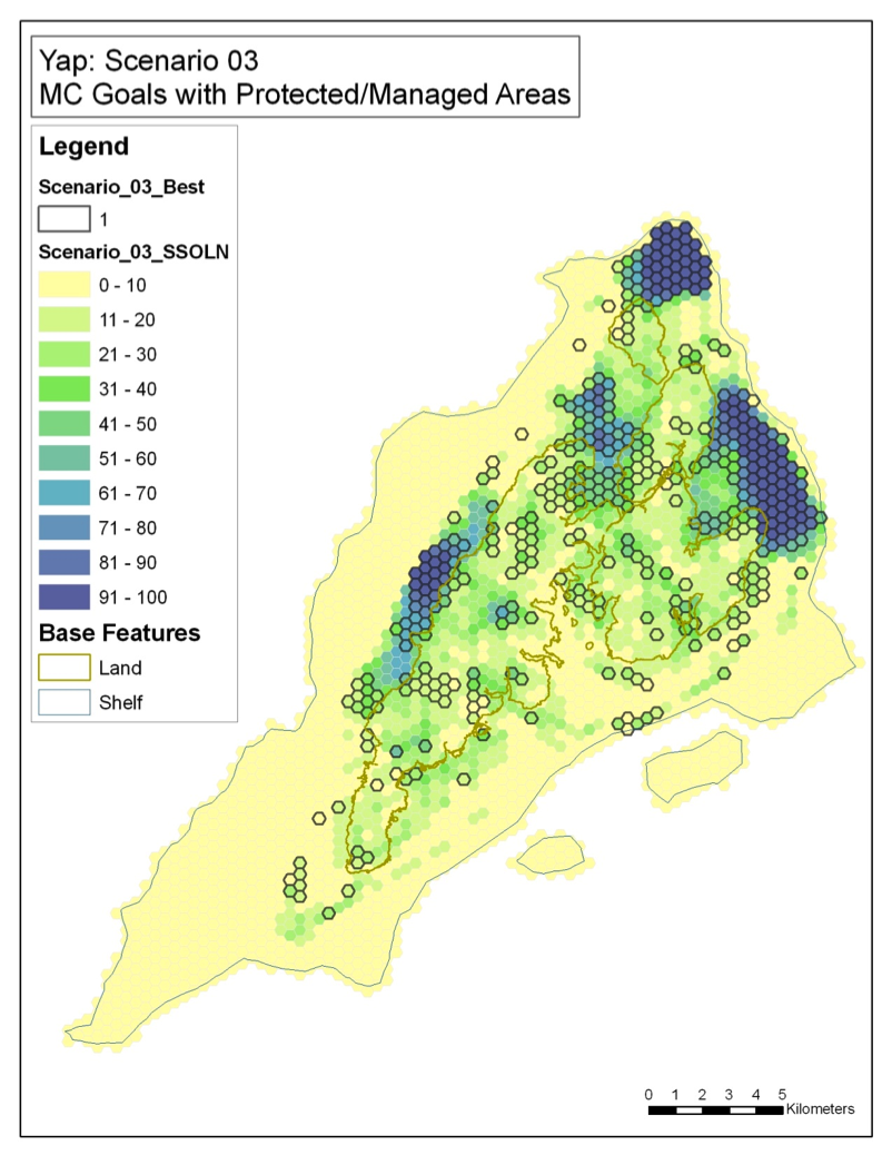
In 2013, the Palau International Coral Reef Center (PICRC) conducted a reef assessment in Yap, Kosrae and Pohnpei to identify areas where reefs were in a reasonable state and where reefs had the capacity to recover if disturbed. Using this data, GIS based maps of reef resilience were developed for the three states. These maps were designed to be used for spatial planning to establish an effective MPA network and to identify where managers can prioritize their actions and resources.
Starting in 2015, The Nature Conservancy, in partnership with state governments and local NGOs, conducted another analysis of protected area sites in the FSM (Pohnpei in 2016, Yap in 2016, Chuuk in 2017, and Kosrae in 2019), to improve the design of each state’s protected area network (PAN). The previous Gap Analysis focused on biodiversity as the number one objective of designated protected areas and did not take into consideration other objectives, especially those of the community. This new approach built on the Gap Analysis by reevaluating the Protected Area (PA) sites in each area using previous research efforts and appropriate community consultations to ensure the PANs meet the goals of both resource managers and community members (e.g., fisheries management), and are representative of biologically significant areas and incorporate resiliency.
An MPA effectiveness assessment tool has been developed for Micronesia, modeled after the MPA Information and Management Effectiveness (MPAME) tool developed in Indonesia. This allows for enhanced understanding of management effectiveness of existing MPA sites to be taken into consideration of the PAN design, regarding whether sites meet state goals and objectives based on management level and conservation effectiveness level. The results of this tools were incorporated into the analysis of existing protected areas. At least 10 years of marine benthic data collected in all 4 states using the MC monitoring protocol was also incorporated into the analysis as well as an additional Rapid Ecological Assessment that was conducted in Chuuk in 2016.

Distribution of coral abundances around Chuuk in 2016. Circle size is proportional to total coral cover in 2016 (range from 3% to 67%), colours indicate proportional cover of the three groups used for analyses. Source: Houk et al. 2016
The outputs of this PAN analysis included recommendations on the design of existing protected areas and prioritized areas for new sites. One major output was the development of a spatial planning score card that allowed communities to assess the design of their respective MPA around certain criteria prioritized to help them achieve their goals. As a result of this work, there has been a focus on creation of mangrove protected areas because of their importance as nursery habitat. Also, several proposed or existing MPAs were redesigned based on recommendations from this work. In particular, an originally proposed site, Palikir Pass MPA in Pohnpei, was deemed inadequate for protecting target species and was therefore expanded to include both the reef pass, mangroves, and seagrass habitat.
At the national level, to assist with the establishment of PAN, in 2015 the FSM developed the PAN National Guiding Policy Framework (2015) adopted in 2018 (CR 20-87 C.D. 1) as the “PAN Policy Framework”. This Framework defines a PA as “an area designated by a state in accordance with its procedures and/or legislation to be protected”, with “protected” meaning “maintained, intact, preserved, conserved, or otherwise managed in a sustainable manner”. For inclusion in PAN, this requires that a PA have a clear Management Plan and a Management Unit (MU) responsible for implementing the plan. The MU could be made up of government, municipal, community, other representatives, or a combination of any or all.
The PAN Policy Framework was established as a transparent, fair, and efficient system governing the designation and operation of a nationwide PAN. The PAN Operations Manual was then developed in response to a need for guidelines to implement the PAN across each State, making clear the benefits of membership in the PAN, requirements and recordkeeping needs, and support at the individual protected area level for development of a PA.
Across the FSM there are more than 50) PA sites, with great variations in management effectiveness. Each FSM state also varies in the completeness of their institutional and legal frameworks related to Protected Areas. Most of the states had some form of PA legislation by the end of 2020 but required the development of regulations or updates to ensure alignment with the PAN Policy Framework.

Facilitated community planning engagement in Riken Village in Yap, December 2020. This engagement partnership is made up of FSM Ridge to Reef Project, Yap Protected Areas Network Coordinator, Yap Marine Resources Management Division, Yap Community Action Program, and with technical support and mentoring from The Nature Conservancy (TNC). Photo © Berna Gorong/TNC
How successful has it been?
Although the original Gap Analysis process was participatory and well-received in the beginning, without a dedicated lead with enough time and resources to follow-up and continue coordinating, the effort stagnated. However, the re-launched state process was well received as it focused on each states’ needs. TNC developed goals and objectives at the state level and then developed design criteria around the objectives. TNC ran the spatial analysis based on these criteria and objectives (additional details on the legislation passed is discussed above). The situation in the FSM remains complex because the states have autonomy and jurisdiction over near shore waters, and the national government has little authority. The effort was designed as a national effort driven by the Convention on Biodiversity (CBD), but realistically it needs to be tackled state by state.
Lessons learned and recommendations
- It is important to be able to support local organizations working with communities when designing and establishing protected areas, and offering assistance in identifying potential alternative livelihoods, as they are often the resource owners or those who have the greatest stake in the resources (e.g., providing facilitation/tools for site-based planning workshops, identifying sources of funding and assisting with proposal review, enabling site exchanges between local partners to share experiences and lessons learned, etc.).
- It has been very helpful to establish a regional support team comprised of key organizations, agencies, and institutions, and to assist the jurisdictions, including the FSM, in their efforts to achieve the goals of the Micronesia Challenge.
- The Micronesians in Island Conservation Network (MIC) has been a successful means of assisting local partners to strengthen their organizations and agencies by providing opportunities for organizational effectiveness assessments, strategic planning, and developing measures of success.
- Having supportive language in the national priority document/guidelines made it easier to integrate resilience principles into management and planning (i.e., aligning the blueprint with the national effort).
- One of the most effective ways to incorporate resilience has been through planning at both the priority-setting and site-based levels.
- Declaration of the Micronesia Challenge has been a catalyst for creating a regional web of mutually reinforcing projects, programs, and peer-learning networks to improve the condition and management of the essential ecosystems and natural resources on which the people of Micronesia rely.
- Passing of the National Protected Areas Network Policy Framework (NPANPF) and State level PAN legislation, which allows for access to long-term and sustained technical and financial assistance is key to improving the management effectiveness of marine protected areas.
- Technical support through the Pacific Island Managed and Protected Area Community (PIMPAC) provides opportunities for information, expertise, practice, and experience exchange to enable and support site-based and ecosystem-based management capacity. It has a number of state and national-level partners across the FSM and provides training for all-important capacity building in the sphere of marine conservation.
- Improving protection for species with larger home ranges will require either making some MPAs larger, or alternative management measures for those species, such as catch, size, gear or effort restrictions, or seasonal catch and/or sale bans.
- While MPAs can protect against negative effects of overfishing of reef fish and invertebrates, they cannot reduce threats from poor land management practices. Degradation and destruction of forests and mangroves negatively impacts downstream habitats and was identified as a key challenge to be addressed by all states. Reducing land-based threats will improve the effectiveness of existing MPAs.

Facilitated community planning engagement in Riken Village in Yap, December 2020. Photo © Berna Gorong/TNC
Funding summary
David and Lucile Packard Foundation
DOI Office of Insular Affairs
NOAA Coral Reef Conservation Program
TNC Early Action Grants
Lead organizations
AFSM Department of Resources and Development
Division of Resource Management & Development
The Nature Conservancy Micronesia Program
Partners
Chuuk Conservation Society
Chuuk State Government
College of Micronesia
Communities and Municipal Governments in Chuuk, Kosrae, Pohnpei, and Yap
Conservation Society of Pohnpei
Government of the Federated States of Micronesia
Kosrae Conservation and Safety Organization
Kosrae State Government
Locally Managed Marine Area Network
Micronesia Conservation Trust
NOAA
Pacific Island Managed and Protected Area Community
Palau International Coral Reef Center
Pohnpei State Government
The Nature Conservancy
U.S. Department of the Interior (Office of Insular Affairs, US Fish and Wildlife Service)
U.S. Forest Service
University of Guam
Yap Community Action Program
Yap State Government
Resources
FSM National Biodiversity Strategy and Action Plan
Updated FSM National (and States) Biodiversity Strategy and Action Plan (NBSAPS)
A Blueprint for Conserving the Biodiversity of the Federated States of Micronesia
Conservation Society of Pohnpei, Rapid Ecological Assessment reports