Assessment of 2017 Hurricane Impacts to Coral Reefs in Puerto Rico
Location
Puerto Rico, USA
The challenge
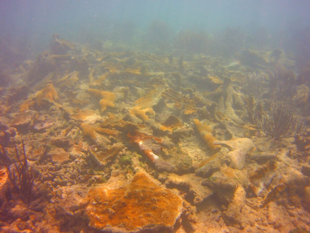
In September 2017, Hurricanes Irma and Maria devastated the islands of Puerto Rico. In addition to the impacts the hurricanes had on land, they also had significant effects on Puerto Rico’s coral reefs, which are the island’s first line of defense against storm waves and flooding. Ad hoc surveys conducted after the hurricanes reported damage ranging from large coral heads being overturned or tossed into sand to extensive burial and breakage. In particular, known previously-dense thickets of the reef-building and Endangered Species Act (ESA) listed elkhorn coral (Acropora palmata) showed significant colony breakage due to the species’ branching morphology and location on the reef as a natural wave break. Extensive damage was also observed to corals from the major Caribbean reef-building genus Orbicella spp. (star coral), that are also ESA-listed species in addition to other coral species. Thus, FEMA assigned NOAA to conduct an island-wide assessment of the impacts of the hurricanes on the coral reefs.

Broken and dislodged fragments of elkhorn coral (Acropora palmata) after the hurricane. Photo © NOAA
In addition to assessing the status of Puerto Rico’s coral reefs after Hurricanes Irma and Maria, FEMA assigned NOAA to conduct emergency triage to salvage and reattach live corals that were still viable. Previous experience has shown that corals that have been physically impacted have a significantly greater chance of survival than those left unattached. It would take decades to regrow the large corals that were impacted, versus minutes to reattach it to the reef. Thus, concurrent with the assessment, emergency triage of highly-impacted reef sites was conducted.
A total of 414,354 m2 of coral reef and over 86,000 corals were surveyed at 153 sites across Puerto Rico between February 25 and May 7, 2018. Approximately 9,760 coral fragments or broken coral colonies were reattached to the reef at 69 sites in the Northeast, North, and Vieques regions between February and June 2018.
Actions taken
NOAA, Puerto Rico Department of Natural Resources, and SeaVentures assessed shallow coral reefs surrounding Puerto Rico and conducted triage stabilization of dislodged corals. We used a probabilistic sampling design for the assessment to allow for statistical inferences from samples to the larger coral reef ecosystem likely to have been damaged by hurricanes. The sample frame covered all known shallow water coral reefs surrounding mainland Puerto Rico, Vieques, Culebra, and the islands within the NE Reserve corridor. The sampling grid, consisting of individual cells measuring 50 x 50 m, was adapted from NOAA’s National Coral Reef Monitoring Program (NCRMP) sample frame, which has been used since 2014 to monitor corals and fishes surrounding Puerto Rico. For this effort, the sample frame was narrowed to focus on coral-dominated habitats in depths less than 7 meters (m), which were those most impacted based on reconnaissance surveys. To increase sampling efficiency and ensure representation from around the islands, the sample frame was stratified by the storm path, discrete coral reef habitats, and geographic region.
The assessment surveys, designed to be as rapid yet quantitative as possible, consisted of two types of in-water diver surveys: a transect survey and a roving survey. The transect survey sites were based on the stratified random sample design described above to allow for statistical representation of areas that have not been surveyed. Divers conducted a line-transect survey at pre-selected site coordinates. The roving survey provided an overview of a larger area outside of the assessment transect that may have had impacts. Roving surveys were also conducted at nonrandom locations informed by expert knowledge of high coral cover of priority species or expected damage.
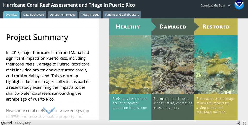
For each assessment site and roving survey area, divers classified damage to site, damage to corals and/or framework, potential as a triage site, and potential as a long-term restoration site. Within survey areas, divers quantified coral species and size class, damage and type of damage, and disease. For both surveys, survey area was noted, GPS points or tracks recorded, and site photographs were collected. Data were recorded into a spatial database and uploaded into an ArcGISOnline Dashboard/Storymap within 1-3 days to inform the triage team about potential sites needing triage.

Puerto Rico Hurricane Assessment and Triage Project Story Map. © NOAA
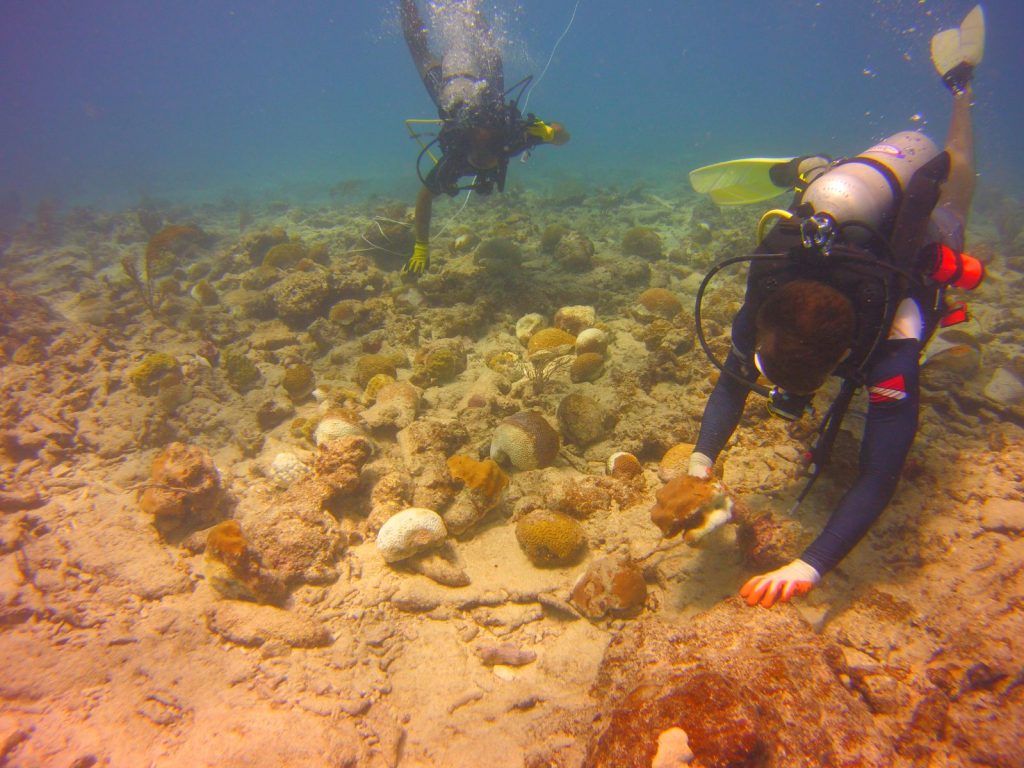
A proportion of corals broken loose or fragmented by the hurricane can remain alive on the bottom, but are at risk of being tumbled by subsequent storm waves, which will continue to reduce the amount of live coral on a reef. By conducting coral triage, these loose at-risk corals were reattached to the reef substratum to minimize the overall hurricane damage at local scales. Triage was conducted at sites identified with the highest level of damage by both reconnaissance and formal assessment surveys focusing on locations with the highest cost benefit. A team of no less than 4 trained divers navigated to the predetermined triage site and prepared gear (e.g., crates, lift bags) and materials (e.g. cement, marmolina) for triage activities. Preparations were made based on the expected numbers, sizes, and species of corals to be reattached at the particular site. Once in the water, divers distributed themselves around the site to begin triage activities. Appropriate locations with open hardbottom were identified to reattach loose corals and avoid disturbing the existing undamaged corals present. Corals and fragments were temporarily cached near restoration locations prior to reattachment. Cement was used to re-attach corals to the substrate. The reef surface was cleaned of turf algae and sediment prior to reattachment to provide for successful adhesion of cement. Spatial data from triage (# corals, area) were also uploaded into the ArcGISOnline Dashboard.

Triage team divers cache corals prior to reattaching them to the reef (Vieques South Bank). Photo © NOAA
How successful has it been?
No quantitative post-triage monitoring has yet been conducted. Informal site visits have shown survival of re-attached corals.
Lessons learned and recommendations
Lessons learned from this project include:
- In some cases, the habitat at the damaged site was not suitable for reattaching the damaged corals (i.e. reduced to rubble). In those cases, the coral fragments were collected and moved to an alternative site better-suited for long-term survival of the corals.
- Having a dedicated data-entry person sped up the data-entry process and facilitated a quick information transfer between the assessment and data-entry teams.
- Off-season weather was challenging.
- Quantification of the assessment and triage allowed for a scientifically rigorous process.
- After the hurricanes, approximately 6 months elapsed prior to the start of the project. The bright-white skeleton signature of recently-dead coral had subsequently been colonized by algae. Therefore, the damage assessment provided by this study is conservative.
Funding summary
Funding for the project was provided by the United States Federal Emergency Management Agency (FEMA) and National Oceanic and Atmospheric Administration (NOAA)
Lead organizations
United States National Oceanic and Atmospheric Administration (NOAA)
Puerto Rico Department of Natural and Environmental Resources (DRNA)
Partners
Resources
Hurricane Coral Reef Assessment and Triage in Puerto Rico ArcGISOnline Dashboard


