Participatory 3D Modeling (P3DM) to Support Climate Preparedness and Response in the Pacific
Location
Boe Boe, Choiseul Province, Solomon Islands; Eastern Highlands and Manus, Papua New Guinea
The challenge
Solomon Islanders are on the front lines of climate change, experiencing rising sea levels, intrusion of saltwater into freshwater supplies, changing rainfall and weather patterns, extreme weather events, and increasing sea temperatures. The Nature Conservancy (TNC) is working with governments, communities, and other partners in the Solomon Islands, Papua New Guinea, and across the Pacific, to build social and ecological resilience to climate change by assessing vulnerability and bolstering climate preparedness through improved community planning and management.
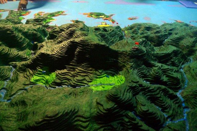
3D model showing aerial view from Snake Ridge to Boe Boe village on the coast in the Solomon Islands. Photo © TNC
Participatory 3D Modeling (P3DM) is a community-based mapping method which brings together local knowledge with elevation data to produce an accurate scale model of lands and waters. Community members integrate local spatial knowledge, land use and cover, and other features on a three-dimensional model using pushpins (points), yarns (lines) and paints (polygons). On completion, data depicted on the model are extracted, digitized and plotted (e.g., in GIS) and the model remains with the community. The models are used to help communities to visualize, discuss, and prepare for threats that affect their water, food, income, and other community services.
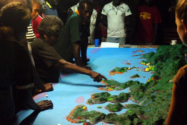
A village elder describes the Boe Boe environment using the 3D model. Photo © TNC
Actions taken
- Two communities (Manus in Papua New Guinea and Boe Boe village in the Solomon Islands) created Participatory 3D models to explore the impacts of climate change and potential responses with Geographic Information System (GIS) support from TNC and partners
- Villagers cut and pasted cardboard to make a relief map of their island; they mapped the community’s crucial infrastructure and resources (e.g., groundwater supplies, schools, clinics, agriculture, rivers, protected forests or reefs, crocodile nesting sites) to visualize what may be threatened by climate change and to inform adaptation options
- University of Wollongong researchers created a digital animation showing projections of king-tides and sea-level rise
- Community discussed impacts of climate change and adaptation responses using the 3D model
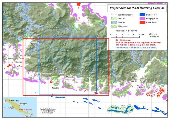
The Project Area Map for the model at 1:5000 scale covering 198 km2 in Choiseul Province, Solomon Islands. Photo © TNC
How successful has it been?
- The development of the Participatory 3D models increased the knowledge of community members regarding the impacts of climate change on their village and strategies for how they can protect themselves
- Villagers visualized how coasts were vulnerable, spurring dialogue about how to best plan for unsustainable land use practices, changing weather patterns, sea-level rise, and tsunami risk (e.g., loss of gardens to saltwater would mean paddling an extra hour or more each day, just to gather food)
- Local knowledge about the forest and marine resources and traditional land boundaries and sacred sites was identified and community elders are recognizing the importance of passing that knowledge to the younger generation. The process has generated excellent discussions between the different generations from each tribal area and enabled important stories and places and oral history to be captured
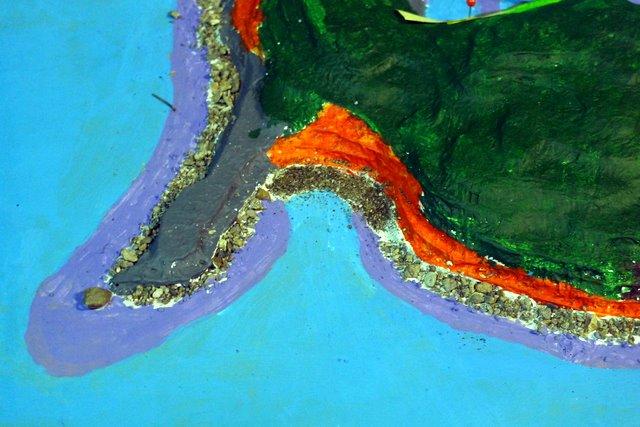
Features include rocky shores, coconut plantations, and reefs. Photo © TNC
Lessons learned and recommendations
- Mapping is essential to support management planning for marine and terrestrial resources – Without a map, it’s impossible to visualize the state of resources, which is key to guiding the region toward sustainability and establishing best practices that will ensure the long-term health of local resources.
- When communities build a scale model of their region—it reveals not just natural landmarks but how people relate to the environment as well.
- The process takes time and commitment. In Manus, the workshop was supposed to last for 10 days, ended up taking 2 weeks. Villagers worked nights and weekends to complete the map.
- By leaving the map in the community, it shifts the ownership of the information to the communities themselves rather than outsiders.
- Participatory mapping is a powerful tool for engaging community members of all ages and occupations.
- Climate change vulnerability mapping efforts are laying the groundwork for nature-based solutions to be mainstreamed into local, regional and national development planning.
- Lessons from participatory community planning will be transferable to climate and hazard preparedness here and in other Small Island Developing States around the globe.
- This project reinforced the importance of letting local people take the lead – According to Trish Kas, TNC’s Development Manager in Papua New Guinea, “by facilitating community efforts and helping them to gather traditional knowledge, we can complement their conservation projects with our science and planning expertise, but the impetus for our involvement has to come from them.”
- Using foam sheets to create the 3D models is much more durable than cardboard, and easier to work with. TNC obtains foam sheets from shoe factories where they use the foam to make flip-flops.
- While there is initially a lot of energy and support for the design and building of the model, continued use of the model often declines after the initial stages. Recommendations for ways to keep the models in use include:
- Identifying a “committee” of champions during the building phase that agrees to look after the model and re-visit it periodically; putting any ongoing land management decisions to test with the model.
- Engage a local school and empower a teacher to have lessons on maps and how to use GPS tools.
- Build a model in a “bathtub” (or small pool, etc.) and then flood the model to simulate sea level rise.
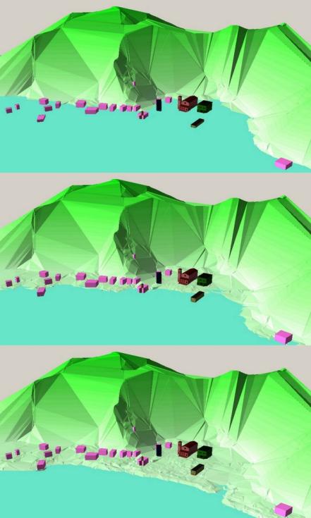
The digital model showing 1m and 2m sea-level inundation in Boe Boe. Photo © TNC
Additional Modeling Efforts
This case study discusses P3DM Boe Boe, which was the second model developed by TNC and partners in the Solomon Islands. Since this initial effort, TNC has led or supported the creation of models in the locations listed below. TNC’s main partner for the P3DM work is a small Papua New Guinea-based NGO, Partners with Melanesians, that continues to build at least one model a year.
TNC P3DM projects:
- Almami LLG, Madang Province, Papua New Guinea (2013)
- Southeast Islands of Manus, Papua New Guinea (2015)
- Melekeok, Palau (2016)
- Gazelle District, East New Britain Province, Papua New Guinea (2017)
- U, Pohnpei, Federated States of Micronesia (2017)
- Kitti, Pohnpei, Federated States of Micronesia (2018)
Funding summary
Lead organizations
Partners
Partners with Melanesians as well as provincial governments and tribal networks
Resources
Video: Modeling the Future in Boe Boe Community, Solomon Islands
Video: Participatory 3D Modelling of Manus Island, PNG
