How do we use our Marine Space? Mapping Human Uses of the East End Marine Park
Location
St. Croix, U.S. Virgin Islands
The challenge
The St. Croix East End Marine Park (STXEEMP) is the U.S. Virgin Islands’ first and largest marine protected area. Its waters are cherished for a variety of commercial and recreational uses by fishers, recreational boaters, charters, hotels, and marinas. The Park also contains extensive mangroves, seagrass beds, coral reefs, sea turtles, beaches, and fish species, which provide invaluable ecosystem benefits. While the extent and health of the biological resources are well understood, human use and social dimensions of the Park are not well researched or documented.
A central objective of marine spatial planning (MSP) is the identification and reduction of conflicts among human uses, and between human uses and the environment. In order to achieve this objective, it is necessary to have accurate and thorough spatial data representing both important and sensitive benthic habitats as well as the location, temporal distribution, and intensity of human activities. Unlike datasets related to physical and biological information, coastal human use information is less common in geographic information systems (GIS). However, collecting and putting this information into GIS allows for it to be visualized and analyzed for the purpose of MSP and management. This project filled those human activity data gaps through a coastal use mapping project.
Actions taken
With support from the National Oceanic and Atmospheric Administration’s Coral Reef Conservation Program (NOAA CRCP), The Nature Conservancy (TNC) and the Virgin Islands Department of Planning and Natural resources (USVI DPNR) convened partners and stakeholders to conduct the STXEEMP Coastal Use Mapping Project. Designed to collect information on how a community is using a coastal or marine area, a representative group of stakeholders were invited to provide input on how they use the waters and coastal areas of the Park. In order to ensure accurate representation from users of the STXEEMP, project partners assembled a list of every human activity within the STXEEMP. Key stakeholders from each activity were invited to workshops to represent their knowledge of that activity. This data will help resource managers understand both the range and intensity of key activities.
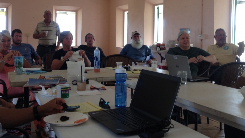
Participants at the coastal mapping project for the St. Croix East End Marine Park represented a number of organizations including national and local government agencies, fishers, hoteliers, charter companies, and recreational boaters. Photo © TNC
Workshops were held with stakeholders on St. Croix on April 16 and 17, 2015, to map key uses in the coastal environment, with a particular focus in the St. Croix East End Marine Park. Representatives from different marine sectors (recreation, watersports, marina, charter boating, SCUBA diving, and fishing industries) as well as NGOs and territorial and federal governmental partners met to provide first-hand information on the spatial and temporal distribution of human use activities in nearshore areas of USVI.
This information was captured using the method of “Participatory GIS Mapping.” Participatory mapping provides participants a map on which to indicate the location of their activities, while moderators generate representative spatial data files in real time. E-Beam™ technology, an interactive tool that allows users to draw electronically on a map, was used to aid the participatory mapping method. During the workshops, maps of the STXEEMP were projected on the wall in front of the group. Representative stakeholders of each activity (i.e. snorkeling) walked to the front of the room and electronically mapped the location while the group provided input.
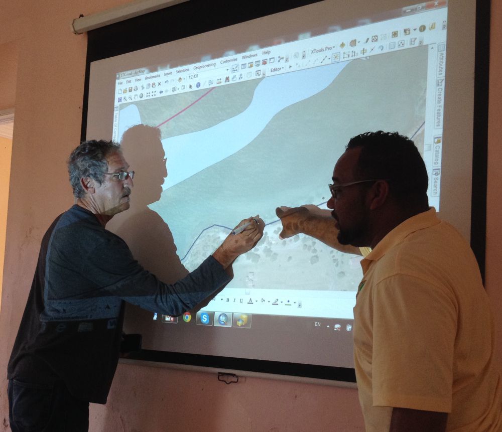
Participant mapping coastal activities using E-Beam™ technology. Photo @ TNC
This work represents an ongoing effort by TNC, USVI DPNR, NOAA CRCP, and members of the Caribbean Regional Ocean Partnership (CROP) to update human use data throughout the USVI in support of resource managers and regional MSP.
How successful has it been?
The following human activities and subsequent mapping layers were created during the STXEEMP Human Use Mapping Workshop in April 2015:
- Boat Ramps and Slips
- Marinas
- Moorings
- Recreational and Commercial Boating
- Motorized and Non-motorized Personal Watercraft
- Dive and Snorkeling Sites
- Marine Restoration
- Camping Beach Areas
- Fish and Conch Fishing Area
- Surfing
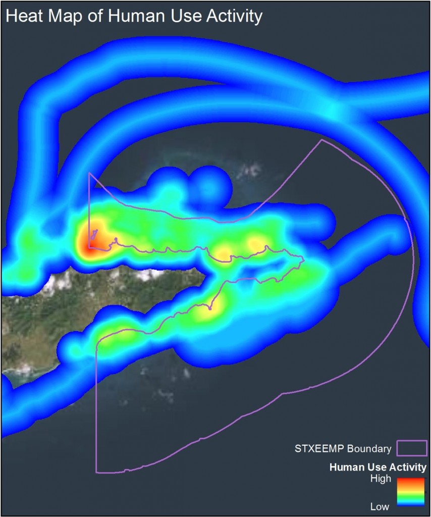
Heat map of cumulative activities shows the most intensely used areas of the STXEEMP. Red and orange areas indicate heavily used areas of the Park. Photo © Lynnette Roth
Data collected during the mapping workshops was made available online to workshop participants, to the general public and resource managers as maps, GIS mapping layers, and analytical products reflecting the variety and extent of ocean uses. Where possible, layers were combined to create a regional file for the entire territory of the USVI.
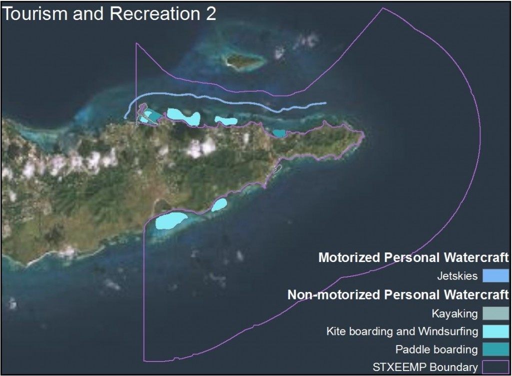
Map of motorized and non-motorized personal watercraft activity (i.e. kayaking) in the STXEEMP. Photo © Lynnette Roth
These data are available to local and regional managers for the purposes of marine spatial planning, management, conflict reduction amongst user groups, and resource protection.
Lessons learned and recommendations
In order to conduct a participatory mapping process, several key factors come into play including:
- Participatory mapping depends on human resources and knowledgeable stakeholders must attend workshops and share their valuable information on human activities. Effort should be put towards recruitment of these stakeholders.
- Technical resources including personnel that can manipulate GIS spatial files is critical.
- Base maps of existing data are critical to getting accurate results.
- E-Beam™ technology facilitates the collection of real time data in a participatory manner.
Funding summary
This project was conducted by The Nature Conservancy with support from the National Oceanic and Atmospheric Administration’s Coral Reef Conservation Program (NOAA CRCP) through Cooperative Agreement #NA13NOS4820145. Through this Partnership, TNC and NOAA work on site level management and conservation strategies for the STXEEMP. The STXEEMP management and staff supported the project by identifying stakeholders, creating outreach materials and advertising the event.
Lead organizations
Partners
USVI Department of Planning and Natural Resources, Coastal Zone Management, East End Marine Park
National Oceanic and Atmospheric Administration Coral Reef Conservation Program
