Challenges of Marine Remote Sensing
Remote Sensing in the marine environment has its own particular set of additional challenges compared to terrestrial remote sensing. For example, the water surface, water depth, and water clarity (turbidity) affect light penetration.
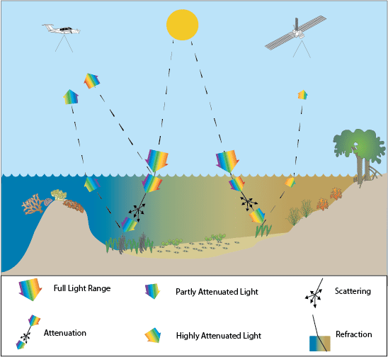
Three challenges of remote sensing shallow marine habitats such as coral reefs and seagrass. Image © Remote Sensing Toolkit
The above graphic shows two paths of light through the water:
The path on the left shows the reflection of the light by the surface of the water (glint). The light penetrates the water at an angle (refraction). Light scatters due to the water and other particles in the water as well as the water column (depth). The deeper the light penetrates, the more it becomes attenuated. The light is reflected at the bottom by seagrass and captured by the passive sensor on the plane.
The path on the right shows the light entering the water at an angle (refraction), the effect of scattering due to depth (depth) and water turbidity (water clarity) causing light attenuation. The light is reflected at the bottom by seagrass and captured by the passive sensor on the satellite.
Remote Sensing Toolkit
The Remote Sensing Toolkit, developed by Dr. Chris Roelfsema and Dr. Stuart Phinn at the University of Queensland, is a tool to help managers, scientists, and technicians working in marine, terrestrial, and atmospheric environments navigate the challenges of remote sensing and select the best tools for different scenarios.