Coastal Resilience Tool
Coastal Resilience is a program developed in 2008 to examine nature’s role in reducing coastal community risk through a public-private partnership between The Nature Conservancy, United Nations University, National Oceanic and Atmospheric Administration (NOAA), United States Geological Survey (USGS), Natural Capital Project, Association of State Floodplain Managers, University of California at Santa Cruz, University of Southern Mississippi, Esri, and Alliance for Development Works. The program includes an approach and decision support tool for climate adaptation and resilience planning.
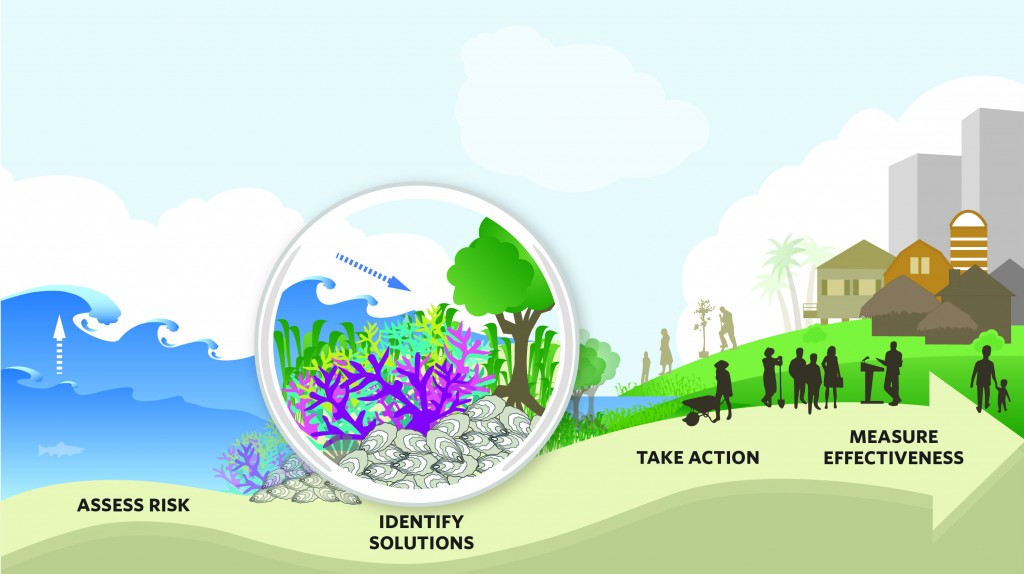
The approach consists of four steps:
- Assess Risk and Vulnerability to coastal hazards including alternative scenarios for current and future storms and sea level rise with community input;
- Identify Solutions for reducing risk focusing on joint solutions across social, economic and ecological systems;
- Take Action at key conservation and restoration demonstration sites to help communities identify and implement nature-based solutions;
- Measure Effectiveness to ensure that efforts to reduce disaster risk and apply ecosystem-based adaptation are successful
An innovative, online decision support tool was developed that includes a mapping platform and suite of customizable web-based apps. The mapping tool is designed to meet planning needs around the U.S. and globally. The tool is focused on identifying nature-based adaptation and mitigation solutions but also includes information for supporting disaster response, coastal habitat restoration and climate change policy efforts. The tool and web apps are customized to specific audiences and scenario planning processes.
In Connecticut, Coastal Resilience was used to inform the community about where marsh advancement will likely occur and to help identify adaptive solutions to improve community resilience. As a result, Connecticut is now the first state in the United States to have assessed the entire coastline for future salt marsh advancement zones down to the parcel scale.
The Coastal Resilience tool works in the U.S. and globally to assess risk and identify risk reduction solutions, operating at national, regional and local scales for more detailed planning in numerous communities. Coastal Resilience’s approach and tool has been rapidly expanding and now include 16 U.S. coastal states (Alabama, California, Connecticut, Florida, Georgia, Hawaii, Louisiana, Maine, Mississippi, New Jersey, New York, North Carolina, South Carolina, Texas, Virginia, Washington), the Caribbean (Grenada, St. Vincent and the Grenadines, U.S. Virgin Islands), and across Mexico and Central America (Belize, Guatemala, Honduras). Having reached almost 100 communities since 2008, The Nature Conservancy intends to increase coverage of the tool and custom web apps to more U.S. states, throughout Mexico and into Southeast Asia in the near future.
The suite of Coastal Resilience web apps enable planners, government officials, and communities to assess risk and identify nature-based solutions to reduce socio-economic vulnerability to coastal hazards. Nature-based adaptation solutions include: protecting or restoring area salt marshes as buffers; developing hybrid approaches that link natural and built defense structures; removing incentives to build in high-risk areas (i.e., often on top of low-lying wetlands); and designing restored oyster and coral reefs as breakwaters.
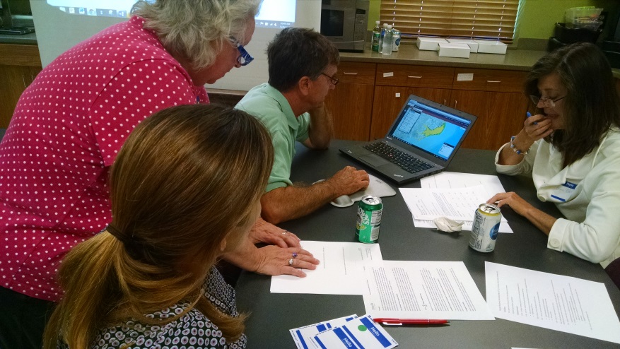
During a Coastal Resilience workshop in North Carolina, attendees work in teams to use the Restoration Explorer App in combination with community-scale ecological, social, and economic data to prioritize subtidal oyster restoration projects for shoreline protection. Photo © TNC
The Coastal Resilience decision support tool allows key stakeholders to compare risk, restoration, and resilience scenarios in an easy-to-use, web-based map interface:
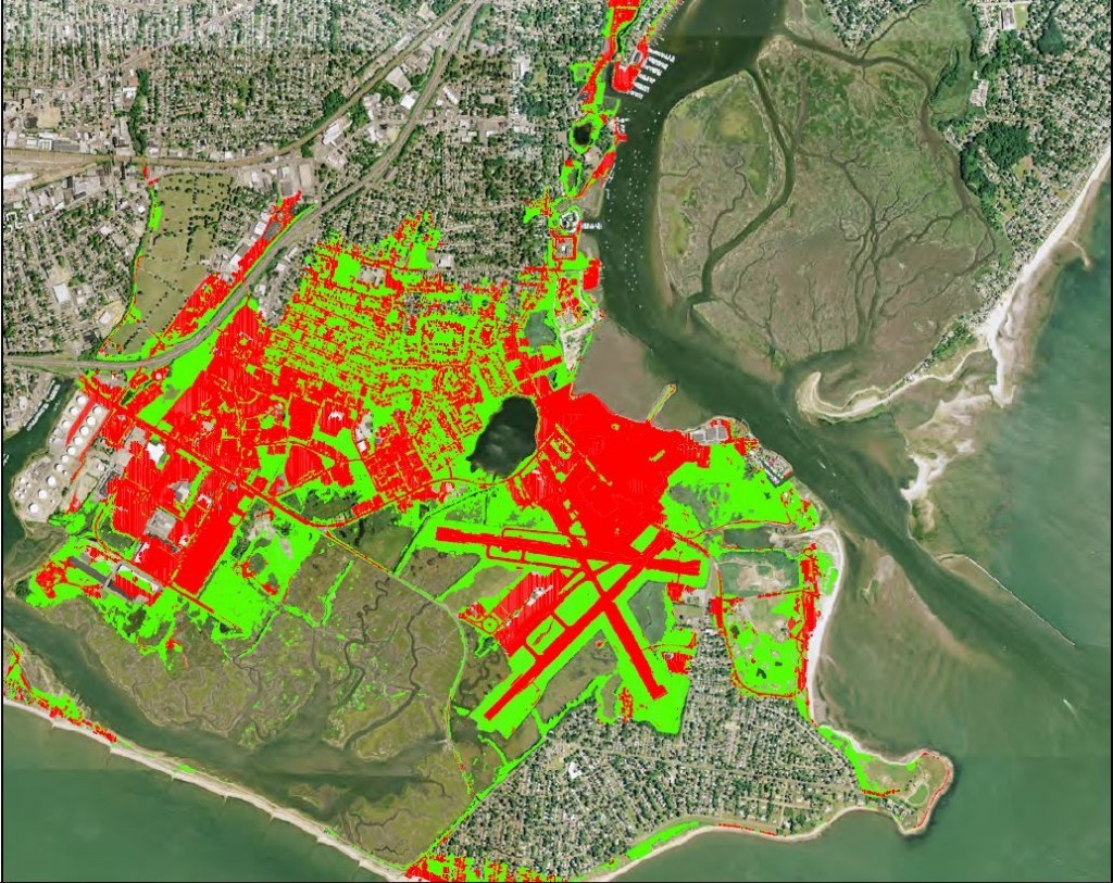
- view potential impacts of sea-level rise, surge from storms and hurricanes, and inland flooding; example in New York
- categorize different scenarios of coastal wetlands moving landward in response to sea-level rise; example in the Gulf of Mexico
- combine data on coastal habitats and exposure ref with socio-economic data to identify solutions where habitat management may most reduce risks along U.S. coasts
- examine coastal defense strategies using green (natural coastal habitats), gray (seawalls, levees, etc.), and hybrid solutions; example in Southeast Florida
- compare risk and vulnerability indicators across countries and determine the critical role of coral reefs and other habitats in disaster risk reduction ref
- examine global risks from natural disasters and effects of environmental degradation in a coasts at risk index ref; global example
The Coastal Resilience approach and decision support tool have been instrumental globally and locally in guiding decisions. For example, regarding Connecticut’s sea level rise policy, the U.S. Navy’s cooperative agreement to actively manage strategic retreat of the naval base in Ventura County, California, and in the recovery of coastal habitats following the Deepwater Horizon oil spill in the Gulf of Mexico. Coastal Resilience is also applied internationally in places such as Grenada for assessing social-ecological vulnerability as well as prioritizing mangrove and coral reef restoration in partnership with the Red Cross, and globally to develop USAID Coasts at Risk indicators and a World Risk Index with Alliance Development Works. Coastal Resilience is also actively being utilized in partnership with the reinsurance industry to determine the costs and benefits of natural infrastructure solutions in reducing risk. The Conservancy has made presentations to and trained various agency partners including Federal Emergency Management Agency (FEMA), Environmental Protection Agency (EPA), NOAA and USGS on the uses and applications of Coastal Resilience, as well as to the Rockefeller Foundation’s 100 Resilient Cities initiative where The Conservancy is the first environmental platform partner, or preferred vendor. Finally, through President Obama’s Climate Action Plan, The Nature Conservancy and the Council on Environmental Quality have been partnering to highlight tools that demonstrate the role of natural resources in risk reduction. A recent fact sheet highlights Coastal Resilience.
Advantages of the Coastal Resilience Tool
- Easy to share and compare risk, restoration, and resilience scenarios through split screen functionality
- Coastal Resilience tool platform is designed to host a series of web apps that can be developed by partners or the open source community. This allows users to explore a specific coastal management issue, respond to a disaster for post-storm decision making, or explore nature-based adaptation options
- The tool platform is a globally distributed network of project sites, meaning that when one Coastal Resilience site advances either the platform itself, or a specific web app, all other geographies leverage, replicate or modify it
- The mapping platform is available on a PC or tablet using any browser with internet connectivity
- The tool operates locally, regionally, nationally and globally, customized to meet specific planning needs, and is easy to share results and data
- Esri and other GIS partners have widely invested in the Javascript Applied Programming Interface (API) making this technology the most cutting edge solution in web mapping tools
- The Coastal Resilience tool is in the process of being upgraded to include Spanish and other languages embedded within the tool; the focus is to ensure the tool is truly global in scope
- The approach and tool have been developed through a public-private partnership
Limitations of the Coastal Resilience Tool
- The tool and web apps perform best with high-speed internet access
- The tool and web apps were not developed for the general public; training is required to engage stakeholders so they can fully utilize the tool, data, and analyses. More information can be found here
- With so many tools now available on the web, it is hard to decipher the niche and therefore use of this tool relative to others that address similar issues. For more information see efforts to demystify the different climate adaptation mapping tools
- The tool has focused mostly in U.S. geographies at local scales, with more recent efforts to expand internationally
- The web apps are viewed within Internet browsers; they are not “native” apps on a mobile device so viewing information on a smart phone is limited
Lessons Learned
- Currently, the majority of investment in the Coastal Resilience program has been on tool development, and not enough emphasis has been placed on communications and outreach of the approach across the different geographies. This has resulted in a lack of awareness of how the tool can be effectively applied to key target audiences.
- Long-term maintenance is needed to keep the data and information in the Coastal Resilience tool up-to-date, often being built for a single planning process or series of stakeholder engagements. This has resulted in a lack of current or relevant information needed to sustain the types of decision support offered by its initial development
When Coastal Resilience was initiated in 2008 there were only a small handful of web-based mapping tools that provided information on sea level rise and storm surge. Thanks to expanding public-private collaborations, there are an increasing number of tools in our collective coastal hazards work shed. Now we need to get smarter about what tool to use in any given planning process, recognize how these tools are complimentary, and further understand how they can be used in different phases of a process that address climate and flooding issues.